Last Updated on Saturday, 27 June 2026, 12:41 by Denis Chabrol
Caracas/New York, 26 June – The earthquakes that struck Venezuela on 24 June caused significant human suffering and loss of life, while also severely affecting livelihoods, infrastructure, and essential services. This includes a preliminary estimate of $6.7 billion in direct physical damage, equivalent to around 6% of GDP, according to a satellite-based Rapid Digital Assessment (RAPIDA) by the United Nations Development Programme (UNDP). While the economic impact is substantial, the greatest loss is borne by the people and communities.
The assessment is based on seismic modelling, satellite imagery and population data and was carried out in the hours after the quake.
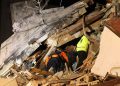
The quakes, measuring magnitude 7.2 and 7.5, hit near Venezuela’s northern coast and were felt across major population and economically important areas, including Caracas and the states of La Guaira, Carabobo, Miranda, Yaracuy, and Aragua. UNDP estimates that 1.7 million structures were in affected areas, including large numbers in the hardest-hit states.
The analysis found that around 8.6 million people were exposed to above moderate shaking across the country’s north, including around 2.1 million exposed to stronger shaking. As of June 26, the official death toll is 920 yet the number of casualties is expected to rise as rescue operations continue. For millions of people across the affected areas, the road to recovery is only just beginning as they struggle to rebuild after devastating losses and uncertain livelihoods.
Direct physical damage is estimated at $6.7 billion (range of $4.7 billion to $8.7 billion), driven by losses to housing and economic assets according to the preliminary assessment. This does not include infrastructure damage, wider economic disruption and longer-term reconstruction costs. While estimated of the total impact is expected to evolve as additional information becomes available, the total impact is typically calculated as 1.5 to 3 times the direct damage.
“The speed and accuracy of early assessments are essential for an effective response,” said Luis Francisco Thais, UNDP Resident Representative in Venezuela. “Tools like RAPIDA help us make faster, evidence-based decisions to support affected communities. At the same time, every crisis is an opportunity to rethink development strategies with resilience at their core. This ensures that recovery not only restores what was lost but also builds a more sustainable future.”
Satellite data also suggests possible power outages in parts of Carabobo, La Guaira, Caracas and Aragua, based on drops in night-time lighting after the quake.
UNDP’s AI-powered Rapid Digital Assessment, RAPIDA, combines satellite imagery and GIS (Geographic Information Systems) technology, to provide instant situational awareness. High-resolution imagery is used to detect damage, identify vulnerable populations, and support coordinated interventions within 72 hours of a crisis.
Further satellite analysis is under way as clearer imagery becomes available to support authorities in assessing casualties and displacement.
Discover more from Demerara Waves Online News- Guyana
Subscribe to get the latest posts sent to your email.