• Contact Us
  • Advertise with us!
  • Classifieds
Sunday, November 1, 2026
  • Login
Demerara Waves Online News- Guyana
  • Home
  • News
    • Premium News
    • Politics
    • Courts
    • Crime
  • Oil & Gas
  • Business
  • Agriculture
  • Health
  • Education
  • Sport
  • Opinion
  • Podcast
  • Contribute Securely
No Result
View All Result
  • Home
  • News
    • Premium News
    • Politics
    • Courts
    • Crime
  • Oil & Gas
  • Business
  • Agriculture
  • Health
  • Education
  • Sport
  • Opinion
  • Podcast
  • Contribute Securely
No Result
View All Result
Demerara Waves Online News- Guyana
No Result
View All Result
Home Business

Guyana, with FAO help, to update maps for the first time in 50 years

Written By Denis Chabrol by Written By Denis Chabrol
Tuesday, 1 November 2022, 22:02
in Business, News
0 0
0
Guyana, with FAO help, to update maps for the first time in 50 years

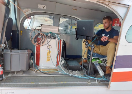
LIDAR mapping personnel

Last Updated on Tuesday, 1 November 2022, 22:02 by Written By Denis Chabrol
LIDAR mapping personnel

The Food and Agriculture Organisation (FAO) on Tuesday said it was assisting Guyana in updating its base maps of the country for the first time in more than 50 years.

“The resulting data will then be entered into key layers to update the national base maps, which are over 50 years old,” that United Nations member organisation said in a statement.

This activity is part of the objectives of the Sustainable Land Development and Management (SLDM) project, which seeks to advance technology in land management and development.

The project is implemented by Guyana Lands and Surveys Commission and the FAO with funding from Guyana’s REDD+ Investment Fund.

The FAO says aerial survey and mapping is being done across Guyana with  laser imaging, detection, and ranging (LIDAR) technologies.

The FAO says the aerial survey will use an aircraft carrying LIDAR sensors and mapping cameras to collect highly accurate and detailed LIDAR and orthophoto maps of the land surface within targeted regions. 

According to the FAO, the data collected will be processed to produce digital terrain models and map imagery for extracting infrastructure, water features, and 3D building models. 

At the end of this exercise, over 500 square kilometres of the urbanised land area and more than 15,000 square kilometres of the rural area will be surveyed using  this new technology. In the coming weeks, international expertise will be provided by Medici Land Governance and its partners to conduct aerial surveying. 

Mr. Enrique Monize, Commissioner of GLSC, today said, “We are excited to see the latest mapping technologies being employed to advance land surveying. Even though LIDAR has been used before in Guyana, this is the first large scale activity that also combines the
traditional imagery with LIDAR for mapping purposes in the country.”

Dr Gillian Smith, FAO Representative, added, “It is our pleasure to support Guyana’s efforts to transform land management and administration.”


Previous Post

New York local politicians deceived in Brooklyn; Guyana govt restates fair governance

Next Post

Body of Guyana-born New York policeman found at Orinduik

Next Post
Body of Guyana-born New York policeman found at Orinduik

Body of Guyana-born New York policeman found at Orinduik

Recent News

Guyana’s ‘Queen of the River’, the Victoria amazonica at the heart of botanical collaboration with Royal Gardens

Guyana’s ‘Queen of the River’, the Victoria amazonica at the heart of botanical collaboration with Royal Gardens

Saturday, 31 October 2026, 13:13
UK to assist with Shell Beach conservation – British High Commission

UK to assist with Shell Beach conservation – British High Commission

Saturday, 31 October 2026, 13:02
Sluggish world oil price affects Guyana’s projected oil earnings

Guyana surpasses one million barrels per day oil production

Saturday, 31 October 2026, 12:40
APNU turns 13; affiliate gets new leader

APNU “deeply concerned” by opposition leader’s remand to prison

Saturday, 31 October 2026, 20:50
Guyana-founded Global Biodiversity Alliance targets US$200 billion annually

Guyana-founded Global Biodiversity Alliance targets US$200 billion annually

Saturday, 31 October 2026, 20:56

Demerara Waves Media Inc. is a Guyana-based digital news media company committed to delivering timely, credible, and relevant news coverage. We report on key national issues, including politics, business, crime, education, health, sports, and culture, serving readers in Guyana and abroad.

Other News and Opinion Wesbsites

  • Caribbean Political Economy
  • The View From Europe
  • Pan Caribbean Voices
  • Huffington Post
  • Caribbean Life
  • New York Daily News
  • New York Post
  • Share News
  • Caricom Headquarters
  • Association of Caribbean States
  • Organisation of Eastern Caribbean States

Recommended News Links

  • Insight Guyana
  • BBC Latin America
  • Prensa Latina
  • Mercopress
  • Inter Press Service
  • Caribbean Media Corporation
  • Al Jazeera
  • Voice of America
  • Business News Americas
  • All Africa
  • Catholic News Agency
  • Xinhaunet China News Agency
  • Home
  • News
  • Oil & Gas
  • Business
  • Agriculture
  • Health
  • Education
  • Sport
  • Opinion
  • Podcast
  • Contribute Securely

© 2026 Demerara Waves Media Inc. | A GxMedia Website Solution.

Welcome Back!

Login to your account below

Forgotten Password?

Retrieve your password

Please enter your username or email address to reset your password.

Log In
No Result
View All Result
  • Home
  • News
    • Premium News
    • Politics
    • Courts
    • Crime
  • Oil & Gas
  • Business
  • Agriculture
  • Health
  • Education
  • Sport
  • Opinion
  • Podcast
  • Contribute Securely

© 2026 Demerara Waves Media Inc. | A GxMedia Website Solution.